

Today, measuring land using a cell phone has become much simpler, since GPS-enabled apps allow you to calculate areas, distances, and perimeters directly on digital maps.
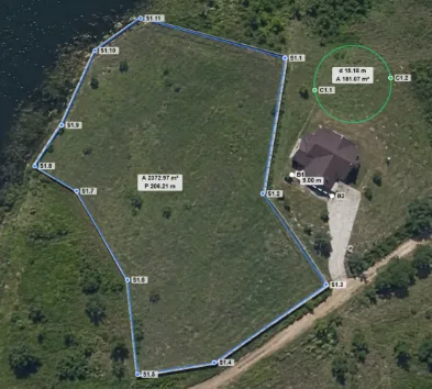
Furthermore, technology has made this type of measurement more accessible to those who need to analyze a property, field, or plot without immediately relying on specific equipment. Therefore, GPS measurement applications have gained traction among landowners, farmers, and professionals who work with land.
In practice, this feature can be used on rural properties, urban land, farms, gardens, construction sites, or during property visits. Simply use your smartphone to mark points on the map or track the area's route and quickly obtain an estimate.
📱 GPS Fields Area Measure: measure any terrain using your cell phone.
O GPS Fields Area Measure It is an application developed to measure areas, distances, and perimeters using maps and GPS resources. In this way, it can transform a cell phone into a practical tool for anyone who needs to analyze the size of a plot of land or delimit a specific area.
Furthermore, the app allows you to work in two ways: the user can manually mark points on the map or use GPS while walking or driving along the area's boundary. This way, you can choose the most convenient method depending on the situation.
The app is available for iPhone and iPad on the App Store and offers features such as area and distance measurement, markers, notes, photos, project saving, and offline functionality. The version found on the App Store also indicates that Premium features are available for advanced tools and cloud storage.
What is GPS Fields Area Measure?
GPS Fields Area Measure is a map-based and location-based measurement application. Primarily, it was designed to make calculating areas and distances easier directly from your mobile phone, eliminating the need for the user to perform all calculations manually.
Furthermore, the application can be used in different contexts, including agriculture, construction, property inspection, and land analysis. The official description highlights precisely these uses, showing that the tool is not limited to a single purpose.
This makes the app interesting both for those who simply want to find out approximately the size of a property and for users who need to organize different measurements during fieldwork.
How does the land measurement app work?
The system works by marking points on the map or using GPS while moving. Therefore, after finding the desired area, the user can start defining the boundaries of the property directly on the screen.
By marking multiple points, the application can form an area and calculate its dimensions. In this way, plots of land with different shapes can be analyzed without relying exclusively on a single geometric figure.
Furthermore, when the user is physically at the location, they can use GPS to track their movement along the area's boundary. The phone then records the route and helps determine the corresponding extent.
How do you measure a plot of land using a map?
To begin, open the app and locate the area you wish to measure on the map. Then, zoom in until you can identify the approximate boundaries of the land.
After that, use the marking tool to add points that represent each part of the boundary. Therefore, if the property has multiple sides, simply add enough points to follow its shape.
Finally, when you close the area, the app displays the measurement result. This way, you can check the estimated size of the land directly on your phone, without having to do the calculations manually.
Is it possible to measure land using GPS?
Yes. In addition to measuring directly on the map, the app offers a GPS-based option. According to the description available on the App Store, it's possible to take measurements while walking or driving through the area, using the device's positioning.
Therefore, this feature can be especially useful for large plots of land, rural areas, and locations where it is easier to physically walk the boundary than to accurately identify it on a map image.
However, it's important to remember that smartphone GPS has limitations. Therefore, the result should be treated as a practical measurement or estimate, especially when the objective involves official documentation, topographic surveying, or decisions that depend on high precision.
What measurements can be calculated?
The GPS Fields Area Measure allows you to work primarily with area, distance and perimeter. In this way, the user can obtain different information about a particular property or space.
Furthermore, the app offers different units of measurement and allows you to adapt the results as needed. This is particularly useful for people who work with rural land, real estate properties, or projects where different units may be used.
Thus, instead of just finding the approximate size of an area, the user can also analyze its perimeter and specific distances between selected points.
Resources for saving terrain information
Another interesting feature is the ability to add information to the marked points. According to the official description, the app allows you to include... notes, photos and personalized data.
Therefore, the user can use the application not only to take isolated measurements, but also to record information related to the area being analyzed. In this way, a visit to a property can generate an organized set of data directly on the mobile phone.
In addition, the app allows you to save, organize, and edit projects. This is very helpful when there are multiple areas to analyze or when a measurement needs to be reviewed later.
Does the app work without internet?
Yes, the version of GPS Fields Area Measure available on the App Store indicates support for offline measurements. This can be especially useful in rural areas or locations with limited internet signal.
Furthermore, this feature makes the app more interesting for activities carried out far from urban centers. After all, land and agricultural properties don't magically appear in a Wi-Fi-enabled area just because you need to measure something.
However, it's important to differentiate between an internet connection and a GPS signal. The functionality of certain features may depend on the location and conditions of the device, so it's worth testing the application before relying on it for an important activity.
GPS Fields Area Measure on Android and iPhone
The app has versions available for mobile devices, but it's important to check exactly which version you're looking for before downloading. In the Brazilian App Store, GPS Fields Area Measure is available for iPhone and iPad.
Furthermore, there are apps with very similar names published on Google Play, which requires attention during installation. Therefore, on Android, carefully check the app name, developer, and information presented in the store before downloading any version.
This way, you avoid confusing the original application with other programs that use similar names to appear in searches for land surveying applications.
How do I download the app?
To download it on your iPhone, open the App Store and search for it. GPS Fields Area Measure. Next, review the information presented on the app's page before tapping the install option.
Additionally, avoid downloading external files or modified versions found on unknown websites. The safest way to install an app on your phone is to use the official app store corresponding to your operating system.
On Android, search for the available version on Google Play and carefully check the developer, description, and security information before installing. Since there are different apps with similar names, this verification is especially important.
Is GPS Fields Area Measure free?
The application appears as free It's available on the App Store, but it also offers in-app purchases. Therefore, it's possible to download the app without paying for the download, while certain features may require a purchase or subscription.
Furthermore, the description itself states that Premium access unlocks advanced tools and cloud storage. Therefore, it's worth checking which features are available for free before subscribing to any additional options.
Since prices and conditions can change depending on the region, platform, and app update, it's best to check the information directly on the official store website before making a purchase.
Security and privacy
Since the application uses location-related resources, it's important to pay attention to the permissions requested during installation and first use. This way, the user can understand what information is needed to use each feature.
Furthermore, location apps should preferably be downloaded from official app stores. Therefore, avoid modified versions or APK files found on unknown websites, especially when the app will be used to record property information.
It is also recommended to keep your operating system and application updated. This way, you can take advantage of fixes and improvements released by the developer and reduce problems related to older versions.
Who might find this app useful?
GPS Fields Area Measure can be useful for landowners who want to better understand the dimensions of an area. Additionally, farmers can use it to analyze fields and organize information related to their properties.
Professionals involved in construction, real estate, and inspections may also find the tool useful. The official description cites applications in agriculture, surveying, construction, and real estate teams.
On the other hand, ordinary users can also take advantage of the feature for simpler situations, such as measuring a backyard, checking a plot of land, or estimating the distance between different points.
Key features that make this app stand out.
One of the main features of GPS Fields Area Measure is the ability to combine maps, GPS, and measurement tools in a single application. This allows the user to choose between manually marking points or using their own movement to record an area.
In addition, the app allows you to add notes and photos to the marked points. This can be quite useful during inspections, because it transforms a simple measurement into a more complete record of the area analyzed.
Another distinguishing feature is its offline functionality, as advertised on the App Store. Therefore, the app may be useful for those who need to work in locations with unreliable internet connections.
There is also the possibility of saving and organizing projects. Thus, instead of redoing a measurement every time a property needs to be consulted, the user can keep the data recorded for future reference.
In addition, the application offers export capabilities in formats such as KML, KMZ, and Shapefile, according to the official description. These formats can be useful in workflows involving maps and geographic data.
Tips for getting the most out of the app
First, clearly identify the boundaries of the land before starting the measurement. The more careful the choice of points, the better the representation of the area on the map tends to be.
Additionally, when using GPS to walk or drive along the property boundary, try to maintain a trajectory as close as possible to the area you wish to measure. This way, the recorded route tends to better represent the desired outline.
Another recommendation is to check the result before saving the measurement. Therefore, after finalizing the area, check if any point is misplaced or if any part of the terrain has not been included.
It's also helpful to use notes and photos when visiting a property. This way, in addition to the calculated area, you can keep additional information related to the location. This feature can greatly facilitate future reference.
Finally, keep the app updated and periodically check the available features. As apps undergo changes over time, some functions, limitations, and terms of use may change.
Conclusion
GPS Fields Area Measure is a practical alternative for those looking for an app to measure land directly from their mobile phone. With GPS and map capabilities, it allows you to calculate areas, distances, and perimeters, as well as record additional information about the analyzed locations.
Furthermore, the ability to mark points, walk around the area using GPS, add photos and notes, and work offline makes the tool useful in different situations. Therefore, it can be an interesting option for owners, farmers, professionals, and users who need a quick estimate.
To download the app, search for GPS Fields Area Measure in your device's official app store and check the available information before installing. This way, you can enjoy the convenience of measuring land with your phone without immediately resorting to more complex tools.
However, for surveys requiring technical precision or official validity, smartphone measurements should not replace a specialized professional. Therefore, use the app as a practical tool for consultation, planning, and estimation, leveraging technology to make tasks that previously required more work much simpler.

